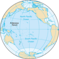
Papeles:Pacific Ocean - en.png
Pacific_Ocean_-_en.png (330 × 330 dagiti piksel, kadakkel ti papeles: 16 KB, kita ti MIME: image/png)
Pakasaritaan ti papeles
Pinduten iti petsa/oras tapno makita ti papeles a kas naiparang iti dayta a panawen.
| Petsa/Oras | Bassit a ladawan | Dagiti rukod | Agar-aramat | Komentario | |
|---|---|---|---|---|---|
| agdama | 03:37, 30 Nobiembre 2023 |  | 330 × 330 (16 KB) | Janitoalevic | . |
| 00:31, 21 Abril 2018 |  | 330 × 330 (17 KB) | Janitoalevic | Transparent background | |
| 20:26, 22 Agosto 2009 |  | 330 × 330 (17 KB) | Serg!o | == Summary == Pacific Ocean map. Source: [https://www.cia.gov/cia/publications/factbook/geos/zn.html CIA World Factbook]. *Slovene version: Image:Pacific Ocean-sl.png == Licensing == {{PD-USGov-CIA-WF}} <!--Categories--> [[Category:Maps of the Pac |
Panagusar iti papeles
Ti sumaganad a 9 a pampanid ket agus-usar iti daytoy a papeles:
- Taaw Pasipiko
- Wikipedia:Napili nga artikulo ita nga aldaw/Abril 19
- Wikipedia:Napili nga artikulo ita nga aldaw/Enero 14
- Wikipedia:Napili nga artikulo ita nga aldaw/Hulio 18
- Wikipedia:Napili nga artikulo ita nga aldaw/Hunio 3
- Wikipedia:Napili nga artikulo ita nga aldaw/Marso 5
- Wikipedia:Napili nga artikulo ita nga aldaw/Nobiembre 30
- Wikipedia:Napili nga artikulo ita nga aldaw/Oktubre 16
- Wikipedia:Napili nga artikulo ita nga aldaw/Septiembre 1
Global a panagusar ti papeles
Dagiti sumaganad a wiki ket agus-usar iti daytoy a papeles:
- Panagusar idiay ace.wikipedia.org
- Panagusar idiay af.wikipedia.org
- Panagusar idiay am.wikipedia.org
- Panagusar idiay as.wikipedia.org
- Panagusar idiay azb.wikipedia.org
- Panagusar idiay ban.wikipedia.org
- Panagusar idiay bew.wikipedia.org
- Panagusar idiay bh.wikipedia.org
- Panagusar idiay blk.wikipedia.org
- Panagusar idiay bn.wikipedia.org
- Panagusar idiay bn.wiktionary.org
- Panagusar idiay br.wikipedia.org
- Panagusar idiay cdo.wikipedia.org
- Panagusar idiay ckb.wikipedia.org
- Panagusar idiay cs.wikipedia.org
- Panagusar idiay dtp.wikipedia.org
- Panagusar idiay dty.wikipedia.org
- Panagusar idiay el.wikipedia.org
- Panagusar idiay en.wikipedia.org
- Pacific Ocean
- Wikipedia:Userboxes/Location
- User:Buaidh
- User:Dpm12/Userboxes
- Wikipedia:WikiProject Oceans
- Wikipedia:Userboxes/Travel
- User:THD3
- Talk:Pacific Ocean/Archive 1
- Template:User interest oceans
- Template:User interest oceans/doc
- Template:User interest Pacific Ocean
- Template:User interest Pacific Ocean/doc
- Template:User WP Oceans
- Template:User WP Oceans/doc
- User:Morriswa/My userboxes
- User:Farmboybello
- User:Solise
- User:Letitgo215
- User:GrapefruitSculpin
- User:Rt26
- User:Yasuo Miyakawa
- User:GravityManFromMegaMan5
- User:Buaidh/Userbox hints
- User:좀비 브렌다
- Wikipedia:Graphics Lab/Illustration workshop/Archive/Nov 2022
- User:Starfruitluver
- User:Maplemoths
- User:Avation user
- File talk:Pacific Ocean - en.png
- Panagusar idiay en.wikibooks.org
Kitaen ti adu pay a global a panagusar iti daytoy a papeles.


