Papeles:UTC hue4map USA-IN.svg

Kadakkel daytoy a panangipadas ti PNG iti daytoy a papeles ti SVG: 391 × 599 dagiti piksel. Sabali kadagiti resolusion: 156 × 240 dagiti piksel | 313 × 480 dagiti piksel | 501 × 768 dagiti piksel | 668 × 1,024 dagiti piksel | 1,337 × 2,048 dagiti piksel | 2,887 × 4,423 dagiti piksel.
Kasisigud a papeles (SVG a papeles, babassit ngem 2,887 × 4,423 pixels, kadakkel ti papeles: 61 KB)
| Daytoy ket papeles a nagtaud manipud idiay Wikimedia Commons. Ti pakaammo manipud iti bukodna a deskripsion a panid idiay ket naiparang dita baba. Ti Commons ket repositorio dagiti nawaya a nalisensiaan a midia. Mabalinmo ti tumulong. |
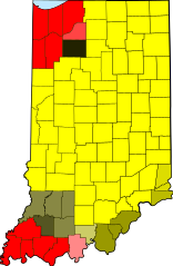
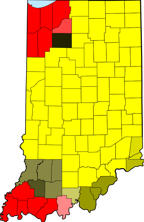
| Deskripsion | tz database zones for the US state of Indiana |
| Petsa | (UTC) |
| Taudan | |
| Mannurat |
|
| This is a retouched picture, which means that it has been digitally altered from its original version. The original can be viewed here: Map of Indiana highlighting Adams County.svg:
|
Siak, ti agtengtengel ti karbengan ti kopia iti daytoy nga obra, ket agipablaak babaen ti sumaganad a lisensia:
| Siak, ti agtengtengel ti karbengan ti kopia iti daytoy nga obra, ibbatak daytoy nga obra iti pagturayan a publiko. Daytoy ket maipakat iti sangalubongan. Kadagiti sabali a pagilian daytoy ket saan a mabalin a nalinteg; no kastoy ket: Siak ket agit-ited iti sinoman ti karbengan nga agusar iti daytoy nga obra para iti ania man a panggep, nga awan dagiti kasasaad, malaksid no adda dagiti kasasaad a masapul babaen ti linteg. |
Kasisigud a listaan pang-ipan
This image is a derivative work of the following images:
- File:Map_of_Indiana_highlighting_Adams_County.svg licensed with PD-self
- 2006-02-12T12:34:48Z David Benbennick 2887x4423 (56998 Bytes) {{subst:User:Dbenbenn/clm|county=Adams County|state=Indiana|type=county}}
Uploaded with derivativeFX
Pakasaritaan ti papeles
Pinduten iti petsa/oras tapno makita ti papeles a kas naiparang iti dayta a panawen.
| Petsa/Oras | Bassit a ladawan | Dagiti rukod | Agar-aramat | Komentario | |
|---|---|---|---|---|---|
| agdama | 18:22, 14 Disiembre 2013 | | 2,887 × 4,423 (61 KB) | Rcsprinter123 | Lake Michigan blue |
| 13:41, 23 Abril 2013 |  | 2,887 × 4,423 (57 KB) | Nyttend | From the beginning, this map has shown the tz database's zones, making any division erroneous | |
| 01:40, 21 Abril 2013 |  | 2,887 × 4,423 (57 KB) | TimeZoneEditor | Reverted to version as of 03:49, 31 May 2012 | |
| 16:05, 16 Agosto 2012 |  | 2,887 × 4,423 (57 KB) | Nyttend backup | From the beginning, this map has shown the tz database's zones, and the database doesn't make a distinction for the two sides of the 1961 line. | |
| 03:49, 31 Mayo 2012 |  | 2,887 × 4,423 (57 KB) | TimeZoneEditor | Reverted to version as of 02:16, 31 May 2012, The IANA version is named "IANA" and located at File:UTC hue4map USA-IN IANA.svg | |
| 03:14, 31 Mayo 2012 |  | 2,887 × 4,423 (57 KB) | Nyttend | No reason to upload a map of a different subject at this name; maps showing different things should be uploaded with different filenames | |
| 02:16, 31 Mayo 2012 |  | 2,887 × 4,423 (57 KB) | TimeZoneEditor | This is not an IANA specific map. | |
| 06:11, 24 Enero 2012 |  | 2,887 × 4,423 (57 KB) | Nyttend | This map shows the tz database's zones, and the database doesn't make a distinction for the two sides of the 1961 line. | |
| 06:09, 24 Enero 2012 |  | 2,887 × 4,423 (58 KB) | MarcusBritish | Match yellows per request at Wiki Graphic Lab. | |
| 10:39, 9 Oktubre 2011 |  | 2,887 × 4,423 (57 KB) | TZ master | change colors to better show 1961 divide |
Panagusar iti papeles
Ti sumaganad a 3 a pampanid ket agus-usar iti daytoy a papeles:
Global a panagusar ti papeles
Dagiti sumaganad a wiki ket agus-usar iti daytoy a papeles:
- Panagusar idiay bn.wikipedia.org
- Panagusar idiay ceb.wikipedia.org
- Panagusar idiay el.wikipedia.org
- Panagusar idiay en.wikipedia.org
- Panagusar idiay es.wikipedia.org
- Panagusar idiay fa.wikipedia.org
- Panagusar idiay fr.wikipedia.org
- Panagusar idiay id.wikipedia.org
- Panagusar idiay ja.wikipedia.org
- Panagusar idiay sco.wikipedia.org
- Panagusar idiay ur.wikipedia.org
- Panagusar idiay zh.wikipedia.org