Papeles:Antarctica, Argentina territorial claim.svg

Kadakkel daytoy a panangipadas ti PNG iti daytoy a papeles ti SVG: 600 × 600 dagiti piksel. Sabali kadagiti resolusion: 240 × 240 dagiti piksel | 480 × 480 dagiti piksel | 768 × 768 dagiti piksel | 1,024 × 1,024 dagiti piksel | 2,048 × 2,048 dagiti piksel | 806 × 806 dagiti piksel.
Kasisigud a papeles (SVG a papeles, babassit ngem 806 × 806 pixels, kadakkel ti papeles: 65 KB)
| Daytoy ket papeles a nagtaud manipud idiay Wikimedia Commons. Ti pakaammo manipud iti bukodna a deskripsion a panid idiay ket naiparang dita baba. Ti Commons ket repositorio dagiti nawaya a nalisensiaan a midia. Mabalinmo ti tumulong. |
| Deskripsion |
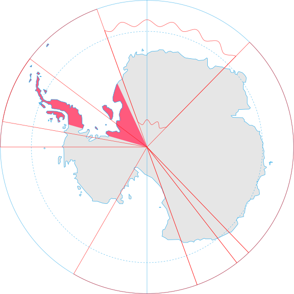
English: Map showing the territorial claim to Antarctica by the country in the filename. Also on the map are is the 60° S Parallel, Antarctic Circle, 0/180 latitude line and (in red) the borders of the claims by other states. |
| Petsa | |
| Taudan | Generated from Antarctica by Lokal_Profil. |
| Mannurat | Lokal_Profil |
| Pammalubos (Ti panagusar manen iti daytoy a papeles) |
Daytoy a papeles ket nalisensiaan babaen ti Creative Commons Attribution-Share Alike 2.5 Generic a lisensia. Pammadayaw: Lokal_Profil
|
Pakasaritaan ti papeles
Pinduten iti petsa/oras tapno makita ti papeles a kas naiparang iti dayta a panawen.
| Petsa/Oras | Bassit a ladawan | Dagiti rukod | Agar-aramat | Komentario | |
|---|---|---|---|---|---|
| agdama | 20:55, 30 Hunio 2008 | | 806 × 806 (65 KB) | Lokal Profil | {{Information |Description={{en|Map showing the territorial claim to Antarctica by the country in the filename. Also on the map are is the 60° S Parallel, Antarctic Circle, 0/180 latitude line and (in red) the borders of the claims by other states.}} |So |
Panagusar iti papeles
Ti sumaganad a panid ket agus-usar iti daytoy a papeles:
Global a panagusar ti papeles
Dagiti sumaganad a wiki ket agus-usar iti daytoy a papeles:
- Panagusar idiay af.wikipedia.org
- Panagusar idiay ar.wikipedia.org
- Panagusar idiay ast.wikipedia.org
- Panagusar idiay az.wikipedia.org
- Panagusar idiay ca.wikipedia.org
- Panagusar idiay chr.wikipedia.org
- Panagusar idiay ckb.wikipedia.org
- Panagusar idiay cs.wikipedia.org
- Panagusar idiay da.wikipedia.org
- Panagusar idiay de.wikipedia.org
- Panagusar idiay diq.wikipedia.org
- Panagusar idiay el.wikipedia.org
- Panagusar idiay en.wikipedia.org
- Panagusar idiay eo.wikipedia.org
- Panagusar idiay et.wikipedia.org
- Panagusar idiay eu.wikipedia.org
- Panagusar idiay fa.wikipedia.org
- Panagusar idiay fi.wikipedia.org
- Panagusar idiay frr.wikipedia.org
- Panagusar idiay fr.wikipedia.org
- Panagusar idiay gl.wikipedia.org
- Panagusar idiay gv.wikipedia.org
- Panagusar idiay hu.wikipedia.org
- Panagusar idiay hy.wikipedia.org
- Panagusar idiay id.wikipedia.org
- Panagusar idiay it.wikipedia.org
- Panagusar idiay ja.wikipedia.org
Kitaen ti adu pay a global a panagusar iti daytoy a papeles.