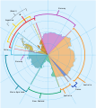
Papeles:Antarctica, territorial claims.svg
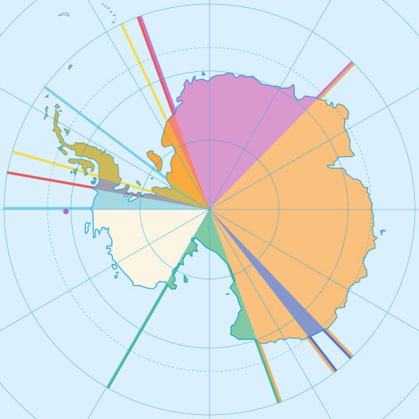
Kadakkel daytoy a panangipadas ti PNG iti daytoy a papeles ti SVG: 600 × 600 dagiti piksel. Sabali kadagiti resolusion: 240 × 240 dagiti piksel | 480 × 480 dagiti piksel | 768 × 768 dagiti piksel | 1,024 × 1,024 dagiti piksel | 2,048 × 2,048 dagiti piksel | 820 × 820 dagiti piksel.
Kasisigud a papeles (SVG a papeles, babassit ngem 820 × 820 pixels, kadakkel ti papeles: 72 KB)
Pakasaritaan ti papeles
Pinduten iti petsa/oras tapno makita ti papeles a kas naiparang iti dayta a panawen.
| Petsa/Oras | Bassit a ladawan | Dagiti rukod | Agar-aramat | Komentario | |
|---|---|---|---|---|---|
| agdama | 16:42, 8 Mayo 2020 |  | 820 × 820 (72 KB) | Spesh531 | Norway's claim stretches to the South Pole as of June 12 2015 |
| 04:31, 13 Oktubre 2009 |  | 820 × 820 (71 KB) | DooFi | sauerkraut | |
| 20:08, 30 Hunio 2008 |  | 806 × 806 (43 KB) | Lokal Profil | {{Information |Description={{en|Map showing the territorial claims to Antarctica}} {{legend|#e987eb|New Zealand}} {{legend|#fcc475|Australia}} {{legend|#8282ed|France}} {{legend|#7efa72|Norway}} {{legend|#ec787f|United Kingdom}} {{legend|#6db87f|Chile}} { |
Panagusar iti papeles
Ti sumaganad a panid ket agus-usar iti daytoy a papeles:
Global a panagusar ti papeles
Dagiti sumaganad a wiki ket agus-usar iti daytoy a papeles:
- Panagusar idiay af.wikipedia.org
- Panagusar idiay ar.wikipedia.org
- Panagusar idiay ast.wikipedia.org
- Panagusar idiay az.wikipedia.org
- Panagusar idiay bn.wikipedia.org
- Panagusar idiay cs.wikipedia.org
- Panagusar idiay de.wikipedia.org
- Panagusar idiay en.wikipedia.org
- Panagusar idiay es.wikipedia.org
- Panagusar idiay eu.wikipedia.org
- Panagusar idiay fa.wikipedia.org
- Panagusar idiay frr.wikipedia.org
- Panagusar idiay fy.wikipedia.org
- Panagusar idiay gl.wikipedia.org
- Panagusar idiay hu.wikipedia.org
- Panagusar idiay hy.wikipedia.org
- Panagusar idiay id.wikipedia.org
Kitaen ti adu pay a global a panagusar iti daytoy a papeles.

