Bohaiseamap2.png(569 × 487 dagiti piksel, kadakkel ti papeles: 136 KB, kita ti MIME: image/png)

Warning sign This file requires updating because: I suggest using the more normative 'Pyongyang' and 'Yellow River' or at least adding these forms in parentheses. In doing so, you could add a timestamp to the file.
Please notify the uploader with {{subst:update-note|1=File:Bohaiseamap2.png|2=I suggest using the more normative 'Pyongyang' and 'Yellow River' or at least adding these forms in parentheses.}} ~~~~

Pakabuklan

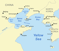
Deskripsion Map of the Bohai Sea and surrounding bays. For a more general map of the same area see Image:Bohai Sea map.png
Petsa
Taudan self-made, based on DCW data.
Mannurat Kmusser
Dagiti sabali a bersion

Derivative works of this file:

This map image could be re-created using vector graphics as an SVG file. This has several advantages; see Commons:Media for cleanup for more information. If an SVG form of this image is available, please upload it and afterwards replace this template with {{vector version available|new image name}}.


It is recommended to name the SVG file “Bohaiseamap2.svg”—then the template Vector version available (or Vva) does not need the new image name parameter.

Lisensia

Siak, ti agtengtengel ti karbengan ti kopia iti daytoy nga obra, ket agipablaak babaen ti sumaganad a lisensia:
w:en:Creative Commons
pammadayaw makibingay nga agpadapada
Daytoy a papeles ket nalisensiaan babaen ti Creative Commons Attribution-Share Alike 2.5 Generic a lisensia.
Nawaya ka:
  • ti makibingay – ti ag-kopia, agiwaras ken agipatulod ti obra
  • ti pagtipon-tipon – ti panagibagay ti obra
Babaen kadagiti sumaganad a kasasaad:
  • pammadayaw – Nasken a mangtedka iti pammadayaw, mangited iti silpo iti lisensia, ken mangibaga no adda dagiti nabaliwan. Mabalinmo nga aramiden iti ania man a pamay-an, ngem iti san a waya a mangisingasing a mangigupit kenka wenno iti panagusarmo.
  • makibingay nga agpadapada – No laokam, baliwam, wenno agpartuat manipud iti dayata material, nasken nga iwaras dagiti kontribusionmo babaen ti kapada wenno maitunos a lisensia a kas ti kasisigud.

Captions

Add a one-line explanation of what this file represents
Map of the Bohai Sea and surrounding bays

Items portrayed in this file

mangipresenta

copyrighted English

MIME type English

image/png

checksum English

e776fb894d1db142a63c8f0d600c8d6c18de759c

data size English

139,100 byte

height English

487 pixel

width English

569 pixel

Pakasaritaan ti papeles

Pinduten iti petsa/oras tapno makita ti papeles a kas naiparang iti dayta a panawen.

Petsa/OrasBassit a ladawanDagiti rukodAgar-aramatKomentario
agdama19:33, 7 Enero 2021Bassit a ladawan para iti bersion manipud idi 19:33, 7 Enero 2021569 × 487 (136 KB)Ras67black frame cropped and alpha channel removed
14:59, 27 Hunio 2007Bassit a ladawan para iti bersion manipud idi 14:59, 27 Hunio 2007583 × 500 (179 KB)Kmusseradded strait
14:50, 27 Hunio 2007Bassit a ladawan para iti bersion manipud idi 14:50, 27 Hunio 2007500 × 429 (141 KB)Kmusser{{Information |Description=Map of the Bohai Sea and surrounding bays. For a more general map of the same area see Image:Bohai Sea map.png |Source=self-made, based on DCW data. |Date=June 27, 2007

Ti sumaganad a 2 a pampanid ket agus-usar iti daytoy a papeles:

Global a panagusar ti papeles

Dagiti sumaganad a wiki ket agus-usar iti daytoy a papeles:

Kitaen ti adu pay a global a panagusar iti daytoy a papeles.

Metadata