Papeles:Coast of Bongao, Tawi Tawi.jpg

Kadakkel daytoy a panagipadas: 800 × 200 dagiti piksel. Sabali kadagiti resolusion: 320 × 80 dagiti piksel | 640 × 160 dagiti piksel | 1,924 × 481 dagiti piksel.
Kasisigud a papeles (1,924 × 481 dagiti piksel, kadakkel ti papeles: 168 KB, kita ti MIME: image/jpeg)
| Daytoy ket papeles a nagtaud manipud idiay Wikimedia Commons. Ti pakaammo manipud iti bukodna a deskripsion a panid idiay ket naiparang dita baba. Ti Commons ket repositorio dagiti nawaya a nalisensiaan a midia. Mabalinmo ti tumulong. |
Pakabuklan
| Deskripsion |
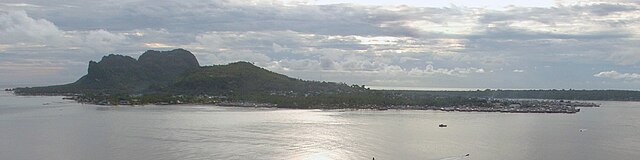
English: Skyline view of Bongao, Tawi Tawi, Philippines (June 14, 2006). |
| Petsa | |
| Taudan | |
| Mannurat | U.S. Navy photo by Chief Photographer's Mate Edward G. Martens |
_Hospital_Ship_USNS_Mercy_(T-AH_19)_is_anchored_off_of_the_coast_of_Tawi_Tawi.jpg)
Lisensia
This file is a work of a sailor or employee of the U.S. Navy, taken or made as part of that person's official duties. As a work of the U.S. federal government, it is in the public domain in the United States.
|
 | |
| Daytoy a papeles ket nainaganan a kas nawaya iti amin nga ammo a pakedngan babaen ti karbengan ti kopia a linteg, a mairaman amin a dagiti makaibagian ken karruba a karbengan. | ||
Pakasaritaan ti papeles
Pinduten iti petsa/oras tapno makita ti papeles a kas naiparang iti dayta a panawen.
| Petsa/Oras | Bassit a ladawan | Dagiti rukod | Agar-aramat | Komentario | |
|---|---|---|---|---|---|
| agdama | 17:11, 2 Septiembre 2014 | 1,924 × 481 (168 KB) | P199 | Cropped version of File:US Navy 060614-N-6501M-006 U.S. Military Sealift Command (MSC) Hospital Ship USNS Mercy (T-AH 19) is anchored off of the coast of Tawi Tawi.jpg using CropTool. |
_Hospital_Ship_USNS_Mercy_(T-AH_19)_is_anchored_off_of_the_coast_of_Tawi_Tawi.jpg)
Panagusar iti papeles
Ti sumaganad a panid ket agus-usar iti daytoy a papeles:
Global a panagusar ti papeles
Dagiti sumaganad a wiki ket agus-usar iti daytoy a papeles:
- Panagusar idiay bcl.wikipedia.org
- Panagusar idiay cbk-zam.wikipedia.org
- Panagusar idiay de.wikivoyage.org
- Panagusar idiay en.wikipedia.org
- Panagusar idiay en.wikivoyage.org
- Panagusar idiay eo.wikipedia.org
- Panagusar idiay es.wikipedia.org
- Panagusar idiay fa.wikipedia.org
- Panagusar idiay fr.wikipedia.org
- Panagusar idiay it.wikipedia.org
- Panagusar idiay ja.wikipedia.org
- Panagusar idiay ka.wikipedia.org
- Panagusar idiay ms.wikipedia.org
- Panagusar idiay mt.wikipedia.org
- Panagusar idiay no.wikipedia.org
- Panagusar idiay pag.wikipedia.org
- Panagusar idiay pam.wikipedia.org
- Panagusar idiay pt.wikipedia.org
- Panagusar idiay simple.wikipedia.org
- Panagusar idiay tl.wikipedia.org
- Panagusar idiay www.wikidata.org