Papeles:Europe countries map en.png
Kadakkel daytoy a panagipadas: 737 × 600 dagiti piksel. Sabali kadagiti resolusion: 295 × 240 dagiti piksel | 590 × 480 dagiti piksel | 944 × 768 dagiti piksel | 1,259 × 1,024 dagiti piksel | 1,475 × 1,200 dagiti piksel.
Kasisigud a papeles (1,475 × 1,200 dagiti piksel, kadakkel ti papeles: 612 KB, kita ti MIME: image/png)
| Daytoy ket papeles a nagtaud manipud idiay Wikimedia Commons. Ti pakaammo manipud iti bukodna a deskripsion a panid idiay ket naiparang dita baba. Ti Commons ket repositorio dagiti nawaya a nalisensiaan a midia. Mabalinmo ti tumulong. |
Pakabuklan
| Deskripsion |
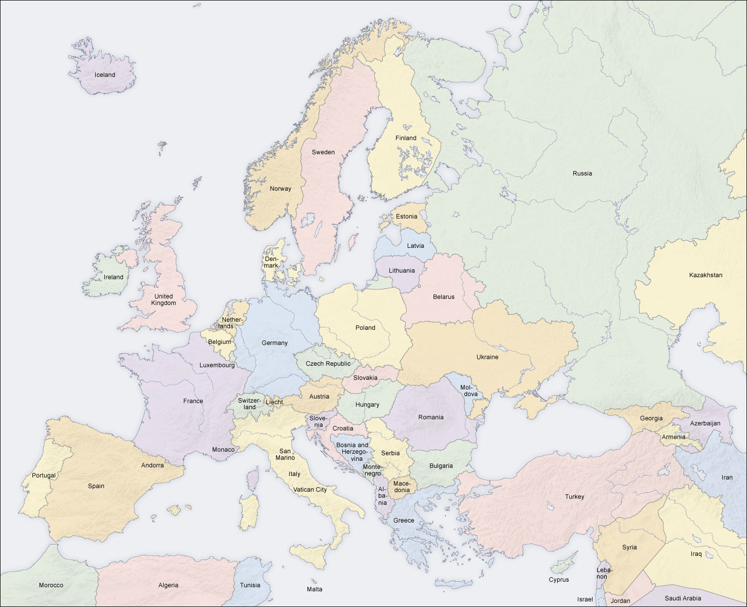
English: Map of countries in Europe |
||||||||||
| Petsa | 02.04.2006 | ||||||||||
| Taudan | Bukod nga obra (Original text: own map, based on the Generic Mapping Tools and ETOPO2) | ||||||||||
| Mannurat | San Jose (map) | ||||||||||
| Pammalubos (Ti panagusar manen iti daytoy a papeles) |
|
||||||||||
| Dagiti sabali a bersion |
Derivative works of this file: []
|


|
This map of europe image could be re-created using vector graphics as an SVG file. This has several advantages; see Commons:Media for cleanup for more information. If an SVG form of this image is available, please upload it and afterwards replace this template with
{{vector version available|new image name}}.
It is recommended to name the SVG file “Europe countries map en.svg”—then the template Vector version available (or Vva) does not need the new image name parameter. |
See also
_en.png)
.png)
.jpg)
| Annotations | This image is annotated: View the annotations at Commons |
Pakasaritaan ti papeles
Pinduten iti petsa/oras tapno makita ti papeles a kas naiparang iti dayta a panawen.
| Petsa/Oras | Bassit a ladawan | Dagiti rukod | Agar-aramat | Komentario | |
|---|---|---|---|---|---|
| agdama | 14:49, 3 Marso 2018 | | 1,475 × 1,200 (612 KB) | Wiz9999 | Reverted to version as of 08:37, 12 June 2008 (UTC) - Please use File:Europe countries map en 2.png to show disputed land. |
| 17:07, 22 Nobiembre 2017 |  | 1,475 × 1,200 (1.32 MB) | Мечников | update | |
| 08:37, 12 Hunio 2008 |  | 1,475 × 1,200 (612 KB) | San Jose | update | |
| 11:52, 5 Hunio 2006 |  | 1,475 × 1,200 (658 KB) | San Jose | updated and corrected | |
| 14:58, 4 Hunio 2006 |  | 1,475 × 1,200 (611 KB) | Roke~commonswiki | montenegro independent now | |
| 11:14, 2 Abril 2006 |  | 1,475 × 1,200 (661 KB) | San Jose | Upload |
Panagusar iti papeles
Ti sumaganad a panid ket agus-usar iti daytoy a papeles:
Global a panagusar ti papeles
Dagiti sumaganad a wiki ket agus-usar iti daytoy a papeles:
- Panagusar idiay da.wikipedia.org
- Panagusar idiay de.wikipedia.org
- Panagusar idiay en.wikipedia.org
- Panagusar idiay haw.wikipedia.org
- Panagusar idiay he.wikipedia.org
- Panagusar idiay hyw.wikipedia.org
- Panagusar idiay nl.wikinews.org
- Panagusar idiay pag.wikipedia.org
- Panagusar idiay roa-rup.wikipedia.org
- Panagusar idiay ro.wikipedia.org
- Panagusar idiay simple.wiktionary.org
- Panagusar idiay su.wikipedia.org
- Panagusar idiay ta.wikipedia.org
- Panagusar idiay uk.wikipedia.org