Papeles:Flores map.png
Awan ti mabalin a nangatngato a resolusion.
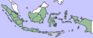
Flores_map.png (300 × 122 dagiti piksel, kadakkel ti papeles: 21 KB, kita ti MIME: image/png)
| Daytoy ket papeles a nagtaud manipud idiay Wikimedia Commons. Ti pakaammo manipud iti bukodna a deskripsion a panid idiay ket naiparang dita baba. Ti Commons ket repositorio dagiti nawaya a nalisensiaan a midia. Mabalinmo ti tumulong. |

|
This locator map image could be re-created using vector graphics as an SVG file. This has several advantages; see Commons:Media for cleanup for more information. If an SVG form of this image is available, please upload it and afterwards replace this template with
{{vector version available|new image name}}.
It is recommended to name the SVG file “Flores map.svg”—then the template Vector version available (or Vva) does not need the new image name parameter. |
This image was copied from wikipedia:en. The original description was:
Map showing Flores Island within Indonesia
| Siak, ti agtengtengel ti karbengan ti kopia iti daytoy nga obra, ibbatak daytoy nga obra iti pagturayan a publiko. Daytoy ket maipakat iti sangalubongan. Kadagiti sabali a pagilian daytoy ket saan a mabalin a nalinteg; no kastoy ket: Siak ket agit-ited iti sinoman ti karbengan nga agusar iti daytoy nga obra para iti ania man a panggep, nga awan dagiti kasasaad, malaksid no adda dagiti kasasaad a masapul babaen ti linteg. |
| date/time | username | edit summary |
|---|---|---|
| 14:17, 14 March 2005 | *drew | (Map showing Flores Island within Indonesia) |
Pakasaritaan ti papeles
Pinduten iti petsa/oras tapno makita ti papeles a kas naiparang iti dayta a panawen.
| Petsa/Oras | Bassit a ladawan | Dagiti rukod | Agar-aramat | Komentario | |
|---|---|---|---|---|---|
| agdama | 10:19, 2 Pebrero 2007 | 300 × 122 (21 KB) | J. Patrick Fischer | The original image was copied from wikipedia:en. The image was corrected by user:J. Patrick Fischer (two islands east of Flores were wrong marked as part of Flores before). The original description was: Map showing Flores Island within Indonesia {{ | |
| 12:26, 10 Oktubre 2006 | 300 × 122 (16 KB) | UtherSRG | Change color. | ||
| 12:27, 5 Oktubre 2005 | 300 × 122 (15 KB) | ChongDae | This image was copied from wikipedia:en. The original description was: Map showing Flores Island within Indonesia {{PD}} {| border="1" ! date/time || username || edit summary |---- | 14:17, 14 March 2005 || *drew || <nowiki>(Map showing Flores Island wi |
Panagusar iti papeles
Ti sumaganad a panid ket agus-usar iti daytoy a papeles:
Global a panagusar ti papeles
Dagiti sumaganad a wiki ket agus-usar iti daytoy a papeles:
- Panagusar idiay az.wikipedia.org
- Panagusar idiay cy.wikipedia.org
- Panagusar idiay el.wikipedia.org
- Panagusar idiay en.wikipedia.org
- Panagusar idiay en.wikivoyage.org
- Panagusar idiay en.wiktionary.org
- Panagusar idiay eo.wikipedia.org
- Panagusar idiay fi.wikipedia.org
- Panagusar idiay fr.wikipedia.org
- Panagusar idiay gl.wikipedia.org
- Panagusar idiay he.wikipedia.org
- Panagusar idiay id.wikipedia.org
- Panagusar idiay it.wikipedia.org
- Panagusar idiay ko.wikipedia.org
- Panagusar idiay min.wikipedia.org
- Panagusar idiay ml.wikipedia.org
- Panagusar idiay nl.wikipedia.org
- Panagusar idiay nn.wikipedia.org
- Panagusar idiay pt.wikipedia.org
- Panagusar idiay tr.wikipedia.org
- Panagusar idiay zh.wikipedia.org