Papeles:HeadwatersGanges1.jpg
Kadakkel daytoy a panagipadas: 487 × 600 dagiti piksel. Sabali kadagiti resolusion: 195 × 240 dagiti piksel | 390 × 480 dagiti piksel | 623 × 768 dagiti piksel | 831 × 1,024 dagiti piksel | 2,000 × 2,464 dagiti piksel.
Kasisigud a papeles (2,000 × 2,464 dagiti piksel, kadakkel ti papeles: 339 KB, kita ti MIME: image/jpeg)
| Daytoy ket papeles a nagtaud manipud idiay Wikimedia Commons. Ti pakaammo manipud iti bukodna a deskripsion a panid idiay ket naiparang dita baba. Ti Commons ket repositorio dagiti nawaya a nalisensiaan a midia. Mabalinmo ti tumulong. |
| Deskripsion |
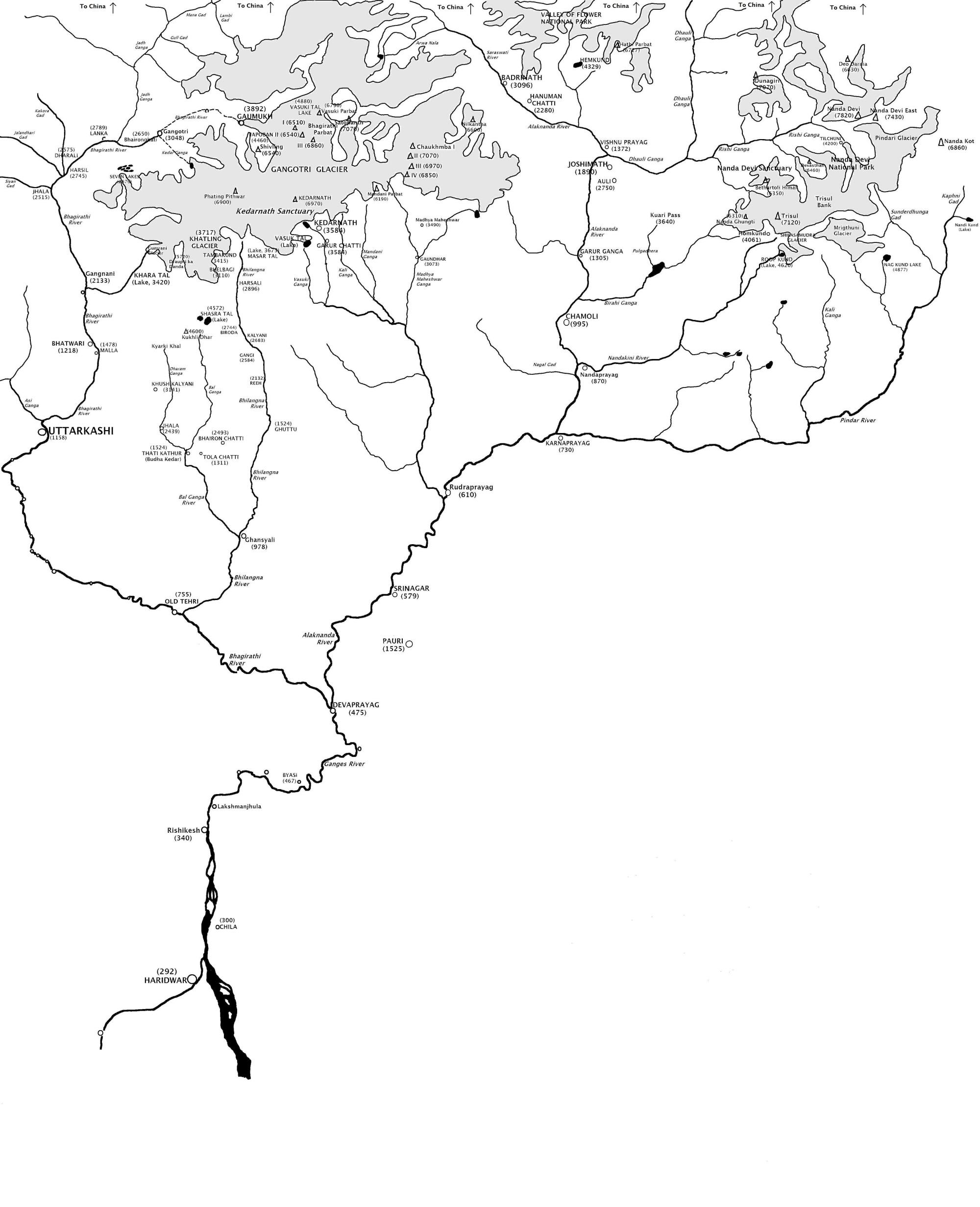
English: Map showing the Himalayan headwaters of the Ganges river of the Indian subcontinent. The map is based on the map in . That map in turn is based on the map of the region produced by the Surveyor General of India. |
| Petsa | |
| Taudan | Bukod nga obra (Original text: I created this work entirely by myself.) |
| Mannurat | Fowler&fowler«Talk» |
| Dagiti sabali a bersion |

Lisensia
[[:w:en:{{{1}}}|{{{1}}}]]
Ni Fowler&fowler at English Wikipedia, ti agtengtengel ti karbengan ti kopia iti daytoy nga obra, ket agipablaak babaen kadagiti sumaganad a lisensia:
Daytoy a papeles ket nalisensiaan babaen ti Creative Commons Attribution-Share Alike 3.0 Unported a lisensia.
Pammadayaw: Fowler&fowler at English Wikipedia
- Nawaya ka:
- ti makibingay – ti ag-kopia, agiwaras ken agipatulod ti obra
- ti pagtipon-tipon – ti panagibagay ti obra
- Babaen kadagiti sumaganad a kasasaad:
- pammadayaw – Nasken a mangtedka iti pammadayaw, mangited iti silpo iti lisensia, ken mangibaga no adda dagiti nabaliwan. Mabalinmo nga aramiden iti ania man a pamay-an, ngem iti san a waya a mangisingasing a mangigupit kenka wenno iti panagusarmo.
- makibingay nga agpadapada – No laokam, baliwam, wenno agpartuat manipud iti dayata material, nasken nga iwaras dagiti kontribusionmo babaen ti kapada wenno maitunos a lisensia a kas ti kasisigud.

|
Maited ti pammalubos ti agkopia, agiwaras ken/wenno mangbaliw iti daytoy a dokumento babaen ti termino iti GNU Free Documentation License, Bersion 1.2 wenno ti ania man a kinaudi a bersion babaen ti Free Software Foundation; nga awan dagiti Sabsabali a Paset, awan dagiti Sanguan nga Aklub a Teksto, ken dagiti Likudan nga Aklub a Teksto. Ti kopia ti lisensia ket nairaman iti paset a natituluan iti GNU Free Documentation License. |
Mabalinmo ti agpili kadagiti lisensia a kaykayatmo.
Kasisigud a listaan pang-ipan
The original description page was here. All following user names refer to en.wikipedia.
- 2009-04-10 21:36 Fowler&fowler 2000×2464× (346958 bytes) {{Information |Description = Map showing the [[Himalayas|Himalayan]] headwaters of the [[Ganges river]] of the [[Indian subcontinent]]. The map is based on the map in {{Harvard reference|editor-last=Agarwala|editor-first=A. P.|title=Uttarakhand Encyc
Pakasaritaan ti papeles
Pinduten iti petsa/oras tapno makita ti papeles a kas naiparang iti dayta a panawen.
| Petsa/Oras | Bassit a ladawan | Dagiti rukod | Agar-aramat | Komentario | |
|---|---|---|---|---|---|
| agdama | 17:55, 22 Hunio 2009 | | 2,000 × 2,464 (339 KB) | Lohen11 | {{Information |Description={{en|Map showing the Himalayan headwaters of the en:Ganges river of the en:Indian subcontinent. The map is based on the map in . That map in turn is based on the map of the region produced by the |
Panagusar iti papeles
Ti sumaganad a panid ket agus-usar iti daytoy a papeles:
Global a panagusar ti papeles
Dagiti sumaganad a wiki ket agus-usar iti daytoy a papeles:
- Panagusar idiay as.wikipedia.org
- Panagusar idiay azb.wikipedia.org
- Panagusar idiay ba.wikipedia.org
- Panagusar idiay bh.wikipedia.org
- Panagusar idiay bn.wikipedia.org
- Panagusar idiay bo.wikipedia.org
- Panagusar idiay ca.wikipedia.org
- Panagusar idiay cv.wikipedia.org
- Panagusar idiay el.wikipedia.org
- Panagusar idiay en.wikipedia.org
- Panagusar idiay es.wikipedia.org
- Panagusar idiay fa.wikipedia.org
- Panagusar idiay fr.wikipedia.org
- Panagusar idiay gu.wikipedia.org
- Panagusar idiay hi.wikipedia.org
- Panagusar idiay ja.wikipedia.org
- Panagusar idiay kbd.wikipedia.org
- Panagusar idiay kn.wikipedia.org
- Panagusar idiay ku.wikipedia.org
- Panagusar idiay kw.wikipedia.org
- Panagusar idiay mai.wikipedia.org
- Panagusar idiay pt.wikipedia.org
- Panagusar idiay ro.wikipedia.org
- Panagusar idiay ru.wikipedia.org
- Panagusar idiay sat.wikipedia.org
- Panagusar idiay simple.wikipedia.org
- Panagusar idiay szy.wikipedia.org
- Panagusar idiay ta.wikipedia.org
- Panagusar idiay tcy.wikipedia.org
- Panagusar idiay te.wikipedia.org
- Panagusar idiay uk.wikipedia.org
Kitaen ti adu pay a global a panagusar iti daytoy a papeles.