Papeles:Kara Sea map.png
Kadakkel daytoy a panagipadas: 658 × 599 dagiti piksel. Sabali kadagiti resolusion: 264 × 240 dagiti piksel | 527 × 480 dagiti piksel | 942 × 858 dagiti piksel.
Kasisigud a papeles (942 × 858 dagiti piksel, kadakkel ti papeles: 258 KB, kita ti MIME: image/png)
| Daytoy ket papeles a nagtaud manipud idiay Wikimedia Commons. Ti pakaammo manipud iti bukodna a deskripsion a panid idiay ket naiparang dita baba. Ti Commons ket repositorio dagiti nawaya a nalisensiaan a midia. Mabalinmo ti tumulong. |

|
This locator map image could be re-created using vector graphics as an SVG file. This has several advantages; see Commons:Media for cleanup for more information. If an SVG form of this image is available, please upload it and afterwards replace this template with
{{vector version available|new image name}}.
It is recommended to name the SVG file “Kara Sea map.svg”—then the template Vector version available (or Vva) does not need the new image name parameter. |
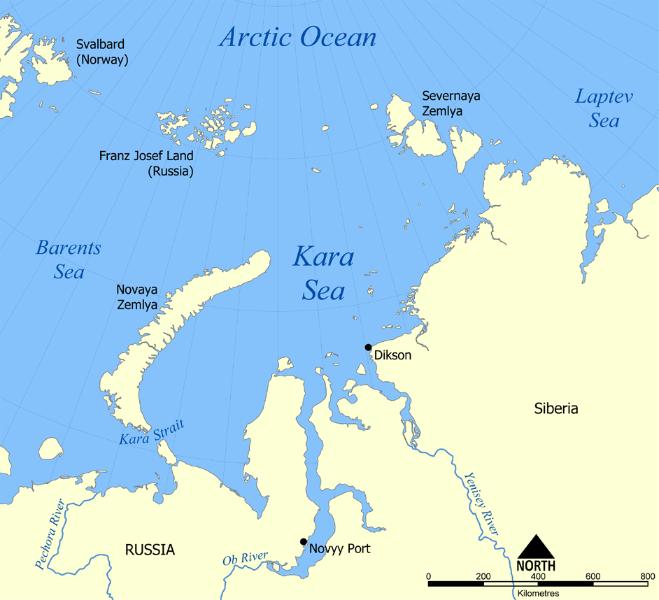
This map shows the location of the Kara Sea north of Russia. The sea is located south of the Arctic Ocean, east of the Barents Sea, west of the Laptev Sea, and is bounded by the Severnaya Zemlya and Novaya Zemlya.
Created by NormanEinstein, November 29, 2005.
Siak, ti agtengtengel ti karbengan ti kopia iti daytoy nga obra, ket agipablaak babaen kadagiti sumaganad a lisensia:

|
Maited ti pammalubos ti agkopia, agiwaras ken/wenno mangbaliw iti daytoy a dokumento babaen ti termino iti GNU Free Documentation License, Bersion 1.2 wenno ti ania man a kinaudi a bersion babaen ti Free Software Foundation; nga awan dagiti Sabsabali a Paset, awan dagiti Sanguan nga Aklub a Teksto, ken dagiti Likudan nga Aklub a Teksto. Ti kopia ti lisensia ket nairaman iti paset a natituluan iti GNU Free Documentation License. |
| Daytoy a papeles ket nalisensiaan babaen ti Creative Commons Attribution-Share Alike 3.0 Unported a lisensia. | ||
| ||
| Daytoy nga etiketa ti panaglisensia ket nainayon iti daytoy a papeles a kas paset iti GFDL a panagbabaro ti panaglisensia. |
Mabalinmo ti agpili kadagiti lisensia a kaykayatmo.
derivative works
Derivative works of this file:
Pakasaritaan ti papeles
Pinduten iti petsa/oras tapno makita ti papeles a kas naiparang iti dayta a panawen.
| Petsa/Oras | Bassit a ladawan | Dagiti rukod | Agar-aramat | Komentario | |
|---|---|---|---|---|---|
| agdama | 20:26, 14 Hulio 2012 | | 942 × 858 (258 KB) | Ras67 | cropped, opt. |
| 22:12, 29 Nobiembre 2005 |  | 952 × 868 (382 KB) | NormanEinstein | This map shows the location of the Kara Sea north of Russia. The sea is located south of the Arctic Ocean, east of the Barents Sea, west of the Laptev Sea, and is bounded by the Severnaya Zemlya and Novaya Zemlya. Created by NormanEinstein, November 29, |
Panagusar iti papeles
Ti sumaganad a panid ket agus-usar iti daytoy a papeles:
Global a panagusar ti papeles
Dagiti sumaganad a wiki ket agus-usar iti daytoy a papeles:
- Panagusar idiay af.wikipedia.org
- Panagusar idiay an.wikipedia.org
- Panagusar idiay ar.wikipedia.org
- Panagusar idiay avk.wikipedia.org
- Panagusar idiay azb.wikipedia.org
- Panagusar idiay az.wikipedia.org
- Panagusar idiay bcl.wikipedia.org
- Panagusar idiay be.wikipedia.org
- Panagusar idiay bg.wikipedia.org
- Panagusar idiay bn.wikipedia.org
- Panagusar idiay br.wikipedia.org
- Panagusar idiay bs.wikipedia.org
- Panagusar idiay ca.wikipedia.org
- Panagusar idiay cs.wikipedia.org
- Panagusar idiay cy.wikipedia.org
- Panagusar idiay da.wikipedia.org
- Panagusar idiay de.wikipedia.org
- Panagusar idiay en.wikipedia.org
- Panagusar idiay en.wiktionary.org
- Panagusar idiay eo.wikipedia.org
- Panagusar idiay es.wikipedia.org
- Panagusar idiay eu.wikipedia.org
- Panagusar idiay fa.wikipedia.org
- Panagusar idiay fi.wikipedia.org
- Panagusar idiay frr.wikipedia.org
- Panagusar idiay fr.wikipedia.org
Kitaen ti adu pay a global a panagusar iti daytoy a papeles.