Papeles:MiyazakiMapCurrent.png

Kadakkel daytoy a panagipadas: 533 × 600 dagiti piksel. Sabali kadagiti resolusion: 213 × 240 dagiti piksel | 427 × 480 dagiti piksel | 801 × 901 dagiti piksel.
Kasisigud a papeles (801 × 901 dagiti piksel, kadakkel ti papeles: 30 KB, kita ti MIME: image/png)
| Daytoy ket papeles a nagtaud manipud idiay Wikimedia Commons. Ti pakaammo manipud iti bukodna a deskripsion a panid idiay ket naiparang dita baba. Ti Commons ket repositorio dagiti nawaya a nalisensiaan a midia. Mabalinmo ti tumulong. |

|
This locator map image could be re-created using vector graphics as an SVG file. This has several advantages; see Commons:Media for cleanup for more information. If an SVG form of this image is available, please upload it and afterwards replace this template with
{{vector version available|new image name}}.
It is recommended to name the SVG file “MiyazakiMapCurrent.svg”—then the template Vector version available (or Vva) does not need the new image name parameter. |
Pakabuklan
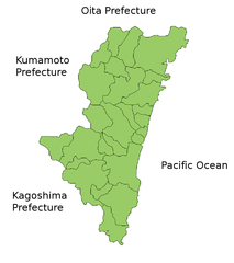
Map of Miyazaki Prefecture, Japan.
Thanks to Aoki Shigenobu and [1]. Colors from Image:TokyoMapCurrent.png by User:Fg2.
Lisensia
| Siak, ti agtengtengel ti karbengan ti kopia iti daytoy nga obra, ibbatak daytoy nga obra iti pagturayan a publiko. Daytoy ket maipakat iti sangalubongan. Kadagiti sabali a pagilian daytoy ket saan a mabalin a nalinteg; no kastoy ket: Siak ket agit-ited iti sinoman ti karbengan nga agusar iti daytoy nga obra para iti ania man a panggep, nga awan dagiti kasasaad, malaksid no adda dagiti kasasaad a masapul babaen ti linteg. |
Pakasaritaan ti papeles
Pinduten iti petsa/oras tapno makita ti papeles a kas naiparang iti dayta a panawen.
| Petsa/Oras | Bassit a ladawan | Dagiti rukod | Agar-aramat | Komentario | |
|---|---|---|---|---|---|
| agdama | 19:24, 22 Marso 2010 | | 801 × 901 (30 KB) | Alberth2 | Nojiri Town was mereged into Kobayashi City and Kiyotake Town was mereged into Miyazaki City. |
| 08:01, 31 Marso 2009 |  | 801 × 901 (31 KB) | Alberth2 | Nangou-chō, Kitagou-chō and Nichinan-shi were megred. | |
| 07:34, 26 Septiembre 2008 |  | 801 × 901 (31 KB) | Alberth2 | Kitagawa was merged into Nobeoka. | |
| 23:59, 23 Hulio 2006 |  | 801 × 901 (30 KB) | Akanemoto~commonswiki | ||
| 15:47, 22 Hulio 2006 |  | 801 × 901 (31 KB) | Akanemoto~commonswiki | ||
| 02:00, 22 Hulio 2006 |  | 801 × 901 (31 KB) | Akanemoto~commonswiki | ||
| 21:25, 21 Hulio 2006 |  | 981 × 901 (32 KB) | Akanemoto~commonswiki | Map of Miyazaki Prefecture, Japan. Thanks to Aoki Shigenobu and [http://aoki2.si.gunma-u.ac.jp/map/map.html]. Colors from Image:TokyoMapCurrent.png by User:Fg2. Category:Maps of Miyazaki prefecture Category:Maps in English |
Panagusar iti papeles
Ti sumaganad a panid ket agus-usar iti daytoy a papeles:
Global a panagusar ti papeles
Dagiti sumaganad a wiki ket agus-usar iti daytoy a papeles:
- Panagusar idiay az.wikipedia.org
- Panagusar idiay ckb.wikipedia.org
- Panagusar idiay cs.wikipedia.org
- Panagusar idiay fa.wikipedia.org
- Panagusar idiay fr.wikipedia.org
- Panagusar idiay incubator.wikimedia.org
- Panagusar idiay lt.wikipedia.org
- Panagusar idiay ms.wikipedia.org
- Panagusar idiay no.wikipedia.org
- Panagusar idiay pam.wikipedia.org
- Panagusar idiay pl.wikipedia.org
- Panagusar idiay ru.wikipedia.org
- Panagusar idiay sah.wikipedia.org
- Panagusar idiay su.wikipedia.org
- Panagusar idiay vi.wikipedia.org