Papeles:Osaka in Osaka Prefecture Ja.svg

Kasisigud a papeles (SVG a papeles, babassit ngem 490 × 690 pixels, kadakkel ti papeles: 30 KB)
| Daytoy ket papeles a nagtaud manipud idiay Wikimedia Commons. Ti pakaammo manipud iti bukodna a deskripsion a panid idiay ket naiparang dita baba. Ti Commons ket repositorio dagiti nawaya a nalisensiaan a midia. Mabalinmo ti tumulong. |
Pakabuklan
| Deskripsion |
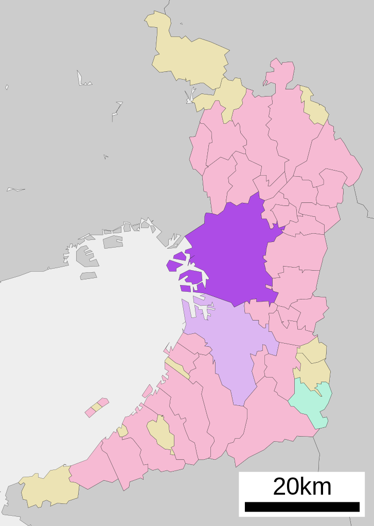
English: Location of Osaka in Osaka Prefecture
|
||
| Petsa | |||
| Taudan |
|
||
| Mannurat | Lincun | ||
| Pammalubos (Ti panagusar manen iti daytoy a papeles) |
|
Lisensia

|
Maited ti pammalubos ti agkopia, agiwaras ken/wenno mangbaliw iti daytoy a dokumento babaen ti termino iti GNU Free Documentation License, Bersion 1.2 wenno ti ania man a kinaudi a bersion babaen ti Free Software Foundation; nga awan dagiti Sabsabali a Paset, awan dagiti Sanguan nga Aklub a Teksto, ken dagiti Likudan nga Aklub a Teksto. Ti kopia ti lisensia ket nairaman iti paset a natituluan iti GNU Free Documentation License. |
- Nawaya ka:
- ti makibingay – ti ag-kopia, agiwaras ken agipatulod ti obra
- ti pagtipon-tipon – ti panagibagay ti obra
- Babaen kadagiti sumaganad a kasasaad:
- pammadayaw – Nasken a mangtedka iti pammadayaw, mangited iti silpo iti lisensia, ken mangibaga no adda dagiti nabaliwan. Mabalinmo nga aramiden iti ania man a pamay-an, ngem iti san a waya a mangisingasing a mangigupit kenka wenno iti panagusarmo.
- makibingay nga agpadapada – No laokam, baliwam, wenno agpartuat manipud iti dayata material, nasken nga iwaras dagiti kontribusionmo babaen ti kapada wenno maitunos a lisensia a kas ti kasisigud.
Kasisigud a listaan pang-ipan
| This file was moved from Japanese Wikipedia.
See below for original file information. | ||||||||||||||||||||||||
| ||||||||||||||||||||||||
|
| ||||||||||||||||||||||||
Pakasaritaan ti papeles
Pinduten iti petsa/oras tapno makita ti papeles a kas naiparang iti dayta a panawen.
| Petsa/Oras | Bassit a ladawan | Dagiti rukod | Agar-aramat | Komentario | |
|---|---|---|---|---|---|
| agdama | 08:34, 22 Oktubre 2020 | | 490 × 690 (30 KB) | AichiWikiFixer | Updated as File:Map_of_Osaka_Prefecture_Ja.svg |
| 20:16, 17 Abril 2008 |  | 500 × 772 (16 KB) | Krisgrotius | {{Information| |Description= Location of Osaka in Osaka Prefecture |Source= Japanese wiki [http://ja.wikipedia.org/wiki/%E7%94%BB%E5%83%8F:%E5%9F%BA%E7%A4%8E%E8%87%AA%E6%B2%BB%E4%BD%93%E4%BD%8D%E7%BD%AE%E5%9B%B3_27100.svg] |Date=~~~~~ |Author=[[:ja: � | |
| 13:36, 5 Oktubre 2007 |  | 500 × 772 (16 KB) | Lincun | {{基礎自治体位置図画像情報|大阪府|大阪市}} |
Panagusar iti papeles
Ti sumaganad a panid ket agus-usar iti daytoy a papeles:
Global a panagusar ti papeles
Dagiti sumaganad a wiki ket agus-usar iti daytoy a papeles:
- Panagusar idiay arz.wikipedia.org
- Panagusar idiay azb.wikipedia.org
- Panagusar idiay bcl.wikipedia.org
- Panagusar idiay bn.wikipedia.org
- Panagusar idiay ca.wikipedia.org
- Panagusar idiay ceb.wikipedia.org
- Panagusar idiay ckb.wikipedia.org
- Panagusar idiay cr.wikipedia.org
- Panagusar idiay de.wikipedia.org
- Panagusar idiay en.wikipedia.org
- Panagusar idiay es.wikipedia.org
- Panagusar idiay fa.wikipedia.org
- Panagusar idiay fi.wikipedia.org
- Panagusar idiay frr.wikipedia.org
- Panagusar idiay fr.wikipedia.org
- Panagusar idiay fr.wiktionary.org
- Panagusar idiay fy.wikipedia.org
- Panagusar idiay ia.wikipedia.org
- Panagusar idiay id.wikipedia.org
- Panagusar idiay incubator.wikimedia.org
- Panagusar idiay it.wikipedia.org
- Panagusar idiay ja.wikipedia.org
- Panagusar idiay ko.wikipedia.org
- Panagusar idiay mi.wikipedia.org
- Panagusar idiay mk.wikipedia.org
- Panagusar idiay ml.wikipedia.org
- Panagusar idiay ms.wikipedia.org
- Panagusar idiay nl.wikipedia.org
- Panagusar idiay no.wikipedia.org
- Panagusar idiay pnb.wikipedia.org
- Panagusar idiay sat.wikipedia.org
- Panagusar idiay sco.wikipedia.org
- Panagusar idiay sd.wikipedia.org
- Panagusar idiay simple.wikipedia.org
- Panagusar idiay si.wikipedia.org
- Panagusar idiay sk.wikipedia.org
- Panagusar idiay sr.wikipedia.org
- Panagusar idiay tg.wikipedia.org
- Panagusar idiay th.wikipedia.org
Kitaen ti adu pay a global a panagusar iti daytoy a papeles.