Papeles:Philippines.A2002088.0220.1km.jpg

Kasisigud a papeles (1,150 × 1,500 dagiti piksel, kadakkel ti papeles: 417 KB, kita ti MIME: image/jpeg)
| Daytoy ket papeles a nagtaud manipud idiay Wikimedia Commons. Ti pakaammo manipud iti bukodna a deskripsion a panid idiay ket naiparang dita baba. Ti Commons ket repositorio dagiti nawaya a nalisensiaan a midia. Mabalinmo ti tumulong. |
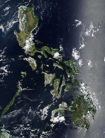
Credit: Jacques Descloitres, MODIS Land Rapid Response Team, NASA/GSFC
Red dots (or outlines in the high-resolution imagery) indicate MODIS9 detection of thermal anomalies throughout the Philippines on March 29, 2002. In most cases, the anomaly is a fire, for example, all the locations marked on the northernmost island, Luzon. However, south of center, on the southern tip of Negros, the thermal anomaly is likely volcanic activity, and the red dot left of center of the main part of Mindanao (lower right) marks the location of a volcano called Mount Ragang.
http://visibleearth.nasa.gov/view_rec.php?id=2656
| This file is in the public domain in the United States because it was solely created by NASA. NASA copyright policy states that "NASA material is not protected by copyright unless noted". (See Template:PD-USGov, NASA copyright policy page or JPL Image Use Policy.) | ||
 |
Warnings:
|
Pakasaritaan ti papeles
Pinduten iti petsa/oras tapno makita ti papeles a kas naiparang iti dayta a panawen.
| Petsa/Oras | Bassit a ladawan | Dagiti rukod | Agar-aramat | Komentario | |
|---|---|---|---|---|---|
| agdama | 21:55, 25 Oktubre 2005 | | 1,150 × 1,500 (417 KB) | Brian0918 | Credit: Jacques Descloitres, MODIS Land Rapid Response Team, NASA/GSFC Red dots (or outlines in the high-resolution imagery) indicate MODIS9 detection of thermal anomalies throughout the Philippines on March 29, 2002. In most cases, the anomaly is a fire |
Panagusar iti papeles
Ti sumaganad a panid ket agus-usar iti daytoy a papeles:
Global a panagusar ti papeles
Dagiti sumaganad a wiki ket agus-usar iti daytoy a papeles:
- Panagusar idiay af.wikipedia.org
- Panagusar idiay ar.wikipedia.org
- Panagusar idiay ast.wikipedia.org
- Panagusar idiay de.wikipedia.org
- Panagusar idiay en.wikipedia.org
- Panagusar idiay es.wikipedia.org
- Panagusar idiay es.wiktionary.org
- Panagusar idiay fr.wikipedia.org
- Panagusar idiay hr.wikipedia.org
- Panagusar idiay it.wikipedia.org
- Panagusar idiay km.wikipedia.org
- Panagusar idiay ko.wikipedia.org
- Panagusar idiay nl.wikipedia.org
- Panagusar idiay pl.wikipedia.org
- Panagusar idiay pl.wikinews.org
- Panagusar idiay pt.wikipedia.org
- Panagusar idiay sh.wikipedia.org
- Panagusar idiay sq.wikipedia.org
- Panagusar idiay tl.wikipedia.org
- Panagusar idiay uk.wikipedia.org