Papeles:Struthio camelus distribution.svg

Kadakkel daytoy a panangipadas ti PNG iti daytoy a papeles ti SVG: 588 × 600 dagiti piksel. Sabali kadagiti resolusion: 235 × 240 dagiti piksel | 470 × 480 dagiti piksel | 753 × 768 dagiti piksel | 1,004 × 1,024 dagiti piksel | 2,007 × 2,048 dagiti piksel | 687 × 701 dagiti piksel.
Kasisigud a papeles (SVG a papeles, babassit ngem 687 × 701 pixels, kadakkel ti papeles: 778 KB)
| Daytoy ket papeles a nagtaud manipud idiay Wikimedia Commons. Ti pakaammo manipud iti bukodna a deskripsion a panid idiay ket naiparang dita baba. Ti Commons ket repositorio dagiti nawaya a nalisensiaan a midia. Mabalinmo ti tumulong. |
Pakabuklan
| Deskripsion |
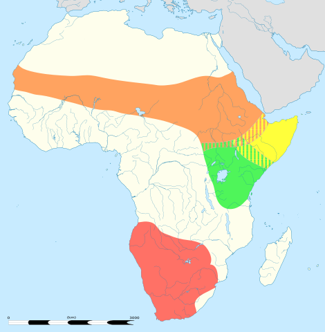
English: An updated version to reflect the correct Southern African distribution as per Sasol Birds of Southern Africa (2011) |
| Petsa |
English: Blank administrative map of political Africa as in 2011-07, for geo-location purposes. On English Wikipedia, in "Template:Location_map_Africa" to set marker along curved latitude/longitude lines. Français : Carte administrative vierge de l'Afrique politique telle qu'en 07/2011, destinée à la géolocalisation. En Wikipédia Francais, a la Modèle:Géolocalisation/Afrique pour carte avec marqueur-image. A Lambert azimuthal equal-area projection, WGS84 datum *Standard meridian: 15°E *Standard parallel: 0° Scale: 1:23,420,000 (precision: 5,855 km) |
| Taudan |
This file was derived from: |
| Mannurat |
|
| Dagiti sabali a bersion | There is a version of this map with key and legends included in the graphic at File:Struthio camelus distribution with key.svg |

| This is a retouched picture, which means that it has been digitally altered from its original version. Modifications: redrawn/vectorised/combined. The original can be viewed here: Africa location map.svg:
|
Lisensia
Daytoy a papeles ket nalisensiaan babaen ti Creative Commons Attribution-Share Alike 3.0 Unported a lisensia.
- Nawaya ka:
- ti makibingay – ti ag-kopia, agiwaras ken agipatulod ti obra
- ti pagtipon-tipon – ti panagibagay ti obra
- Babaen kadagiti sumaganad a kasasaad:
- pammadayaw – Nasken a mangtedka iti pammadayaw, mangited iti silpo iti lisensia, ken mangibaga no adda dagiti nabaliwan. Mabalinmo nga aramiden iti ania man a pamay-an, ngem iti san a waya a mangisingasing a mangigupit kenka wenno iti panagusarmo.
- makibingay nga agpadapada – No laokam, baliwam, wenno agpartuat manipud iti dayata material, nasken nga iwaras dagiti kontribusionmo babaen ti kapada wenno maitunos a lisensia a kas ti kasisigud.
Kasisigud a listaan pang-ipan
This image is a derivative work of the following images:
- File:Struthio_camelus_Distribution_updated.png licensed with Cc-by-sa-3.0
- 2012-09-26T13:18:50Z Metatronx 1038x1270 (28425 Bytes) User created page with UploadWizard
- File:Africa_location_map.svg licensed with Cc-by-sa-3.0, GFDL
- 2012-10-02T12:40:15Z Palosirkka 1525x1440 (792744 Bytes) Reverted to version as of 19:13, 14 July 2011 Location maps must remain very accurate
- 2012-09-12T20:15:41Z Palosirkka 1525x1440 (537042 Bytes) Scrubbed with http://codedread.com/scour/
- 2011-07-14T19:13:55Z Sting 1525x1440 (792744 Bytes) Sudan/South Sudan 2011-07 border update
- 2010-07-02T20:12:15Z Sting 1525x1440 (586394 Bytes) == {{int:filedesc}} == {{Location|00|00|00|N|15|00|00|E|scale:30000000}} {{Information |Description={{en|Blank administrative map of political [[:en:Africa|Africa]], for geo-location purposes.}} {{fr|Carte administrative vier
Uploaded with derivativeFX
Pakasaritaan ti papeles
Pinduten iti petsa/oras tapno makita ti papeles a kas naiparang iti dayta a panawen.
| Petsa/Oras | Bassit a ladawan | Dagiti rukod | Agar-aramat | Komentario | |
|---|---|---|---|---|---|
| agdama | 05:06, 22 Agosto 2013 | | 687 × 701 (778 KB) | Begoon | position/keyline |
| 18:41, 21 Agosto 2013 |  | 687 × 701 (902 KB) | Begoon | and re-crop | |
| 18:22, 21 Agosto 2013 |  | 750 × 705 (901 KB) | Begoon | no legend | |
| 18:07, 21 Agosto 2013 |  | 750 × 705 (932 KB) | Begoon | nah - better how it was | |
| 18:02, 21 Agosto 2013 |  | 750 × 705 (932 KB) | Begoon | reduce legend size | |
| 16:06, 21 Agosto 2013 |  | 750 × 705 (932 KB) | Begoon | tweak - square up legend key blocks after resize | |
| 15:41, 21 Agosto 2013 |  | 750 × 705 (931 KB) | Begoon | shading | |
| 14:31, 21 Agosto 2013 |  | 750 × 705 (914 KB) | Begoon | clearer colours for infobox | |
| 13:11, 21 Agosto 2013 |  | 750 × 705 (919 KB) | Begoon | reduce yellow in land colour to increase yellow distrib area contrast | |
| 12:16, 21 Agosto 2013 |  | 750 × 705 (919 KB) | Begoon | oops - fix crop properly |
Panagusar iti papeles
Ti sumaganad a panid ket agus-usar iti daytoy a papeles:
Global a panagusar ti papeles
Dagiti sumaganad a wiki ket agus-usar iti daytoy a papeles:
- Panagusar idiay af.wikipedia.org
- Panagusar idiay am.wikipedia.org
- Panagusar idiay ar.wikipedia.org
- Panagusar idiay azb.wikipedia.org
- Panagusar idiay ba.wikipedia.org
- Panagusar idiay cs.wikipedia.org
- Panagusar idiay de.wikipedia.org
- Panagusar idiay en.wikipedia.org
- Panagusar idiay es.wikipedia.org
- Panagusar idiay gl.wikipedia.org
- Panagusar idiay is.wikipedia.org
- Panagusar idiay it.wikipedia.org
- Panagusar idiay kn.wikipedia.org
- Panagusar idiay kw.wikipedia.org
- Panagusar idiay lt.wikipedia.org
- Panagusar idiay mk.wikipedia.org
- Panagusar idiay ms.wikipedia.org
- Panagusar idiay my.wikipedia.org
- Panagusar idiay pa.wikipedia.org
- Panagusar idiay pl.wikipedia.org
- Panagusar idiay pt.wikipedia.org
- Panagusar idiay ru.wikipedia.org
- Panagusar idiay sco.wikipedia.org
- Panagusar idiay simple.wikipedia.org
- Panagusar idiay sl.wikipedia.org
- Panagusar idiay tr.wikipedia.org
- Panagusar idiay vi.wikipedia.org
- Panagusar idiay wa.wikipedia.org