Papeles:Sub-Saharan Africa definition UN.png
Awan ti mabalin a nangatngato a resolusion.
Sub-Saharan_Africa_definition_UN.png (362 × 340 dagiti piksel, kadakkel ti papeles: 6 KB, kita ti MIME: image/png)
| Daytoy ket papeles a nagtaud manipud idiay Wikimedia Commons. Ti pakaammo manipud iti bukodna a deskripsion a panid idiay ket naiparang dita baba. Ti Commons ket repositorio dagiti nawaya a nalisensiaan a midia. Mabalinmo ti tumulong. |

|
This map image could be re-created using vector graphics as an SVG file. This has several advantages; see Commons:Media for cleanup for more information. If an SVG form of this image is available, please upload it and afterwards replace this template with
{{vector version available|new image name}}.
It is recommended to name the SVG file “Sub-Saharan Africa definition UN.svg”—then the template Vector version available (or Vva) does not need the new image name parameter. |
| Deskripsion |
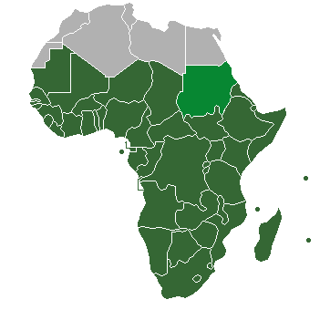
Definition of "Sub-Saharan Africa" as used in the statistics of many the UN institutions. Sudan is also classified as North Africa by the United Nations. |
| Petsa | (UTC) |
| Taudan | |
| Mannurat |
| This is a retouched picture, which means that it has been digitally altered from its original version. Modifications: binary colouring of countries. The original can be viewed here: HDImap spectrum2006 Africa.png:
|
Siak, ti agtengtengel ti karbengan ti kopia iti daytoy nga obra, ket agipablaak babaen ti sumaganad a lisensia:
| Siak, ti agtengtengel ti karbengan ti kopia iti daytoy nga obra, ibbatak daytoy nga obra iti pagturayan a publiko. Daytoy ket maipakat iti sangalubongan. Kadagiti sabali a pagilian daytoy ket saan a mabalin a nalinteg; no kastoy ket: Siak ket agit-ited iti sinoman ti karbengan nga agusar iti daytoy nga obra para iti ania man a panggep, nga awan dagiti kasasaad, malaksid no adda dagiti kasasaad a masapul babaen ti linteg. |
Kasisigud a listaan pang-ipan
This image is a derivative work of the following images:
- File:HDImap_spectrum2006_Africa.png licensed with PD-self
- 2007-03-09T10:43:40Z Dbachmann 356x344 (7521 Bytes) == Summary == Detail of [[:Image:HDImap spectrum2006.png]]. [[:en:United Natiows|UN]] [[:en:Human Development Index|Human Development Index (HDI)]] for 2004, derived from 2006 UN HDI report. An HDI below 0.5 is considered to
Uploaded with derivativeFX
Pakasaritaan ti papeles
Pinduten iti petsa/oras tapno makita ti papeles a kas naiparang iti dayta a panawen.
| Petsa/Oras | Bassit a ladawan | Dagiti rukod | Agar-aramat | Komentario | |
|---|---|---|---|---|---|
| agdama | 20:47, 19 Hulio 2013 | | 362 × 340 (6 KB) | Maproom | Reshaded South Sudan, which the UN now regards as in East Africa, not North Africa: see http://unstats.un.org/unsd/methods/m49/m49regin.htm |
| 13:27, 12 Abril 2012 |  | 362 × 340 (9 KB) | Hazhk | Adding different shading for Sudan & S. Sudan because they're also classified as being part of North Africa by the UN | |
| 22:02, 9 Hulio 2011 |  | 356 × 344 (11 KB) | Maphobbyist | South Sudan has become independent on July 9, 2011. Sudan and South Sudan are shown with the new international border between them. | |
| 06:46, 31 Marso 2011 |  | 356 × 344 (10 KB) | Hoshie | added Cabinda (Angola) to map | |
| 11:18, 15 Disiembre 2010 |  | 356 × 344 (6 KB) | Jcherlet | {{Information |Description=Definition of Sub-Saharan Africa, according to the United Nations institutions |Source=*File:HDImap_spectrum2006_Africa.png |Date=2010-12-15 11:13 (UTC) |Author=*Jcherlet: '''Jcherlet''' *derivative work: |
Panagusar iti papeles
Ti sumaganad a panid ket agus-usar iti daytoy a papeles:
Global a panagusar ti papeles
Dagiti sumaganad a wiki ket agus-usar iti daytoy a papeles:
- Panagusar idiay ast.wikipedia.org
- Panagusar idiay ca.wikipedia.org
- Panagusar idiay ckb.wikipedia.org
- Panagusar idiay cs.wikipedia.org
- Panagusar idiay de.wikipedia.org
- Panagusar idiay en.wikipedia.org
- Sub-Saharan Africa
- Water supply and sanitation in sub-Saharan Africa
- Wikipedia:Reference desk/Archives/Humanities/2013 October 5
- Category:Birds of Sub-Saharan Africa
- Category:Fauna of Sub-Saharan Africa
- Category:Biota of Sub-Saharan Africa
- Category:Mammals of Sub-Saharan Africa
- User:DexDor/Categorization of organisms by geography
- Category:Moths of Sub-Saharan Africa
- Category:Amphibians of Sub-Saharan Africa
- Panagusar idiay et.wikipedia.org
- Panagusar idiay ha.wikipedia.org
- Panagusar idiay he.wikipedia.org
- Panagusar idiay id.wikipedia.org
- Panagusar idiay ig.wikipedia.org
- Panagusar idiay it.wikipedia.org
- Panagusar idiay ja.wikipedia.org
- Panagusar idiay ka.wikipedia.org
- Panagusar idiay ko.wikipedia.org
- Panagusar idiay lt.wikipedia.org
- Panagusar idiay pa.wikipedia.org
- Panagusar idiay pnb.wikipedia.org
- Panagusar idiay ro.wikipedia.org
- Panagusar idiay simple.wikipedia.org
- Panagusar idiay sr.wikipedia.org
- Panagusar idiay sv.wikipedia.org
- Panagusar idiay ta.wikipedia.org
- Panagusar idiay th.wikipedia.org
- Panagusar idiay tn.wikipedia.org
- Panagusar idiay tr.wikipedia.org
- Panagusar idiay ur.wikipedia.org
Kitaen ti adu pay a global a panagusar iti daytoy a papeles.