Papeles:The Danube Spills into the Black Sea.jpg

Kadakkel daytoy a panagipadas: 669 × 600 dagiti piksel. Sabali kadagiti resolusion: 268 × 240 dagiti piksel | 535 × 480 dagiti piksel | 857 × 768 dagiti piksel | 1,142 × 1,024 dagiti piksel | 2,080 × 1,865 dagiti piksel.
Kasisigud a papeles (2,080 × 1,865 dagiti piksel, kadakkel ti papeles: 1.07 MB, kita ti MIME: image/jpeg)
| Daytoy ket papeles a nagtaud manipud idiay Wikimedia Commons. Ti pakaammo manipud iti bukodna a deskripsion a panid idiay ket naiparang dita baba. Ti Commons ket repositorio dagiti nawaya a nalisensiaan a midia. Mabalinmo ti tumulong. |
Pakabuklan
| Deskripsion |
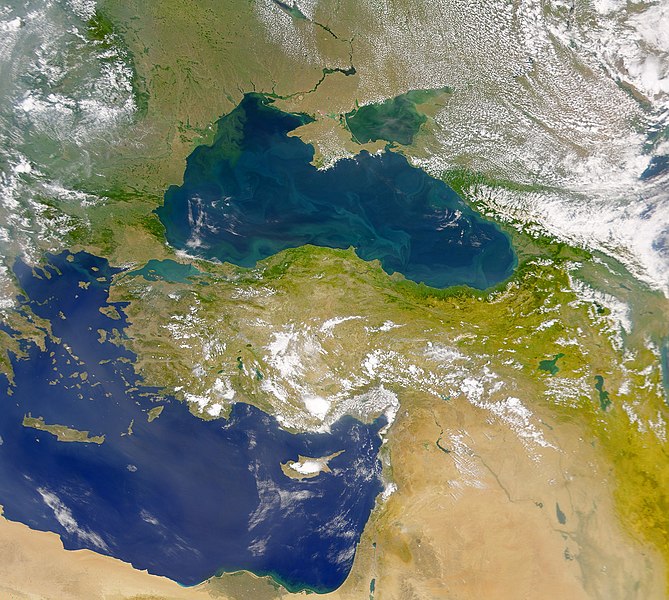
English: This cloud-free Sea-viewing Wide Field-of-view Sensor (SeaWiFS) view of the Black Sea reveals the colourful interplay of currents on the lake’s surface. The green crescent shaped pattern in the north-western corner of the Black Sea is due to the nutrient-rich, sediment-laden discharge of the Danube River stimulating biological activity. The brighter, more turquoise patterns on the lake to the south and east are probably blooms of another type of phytoplankton. |
| Petsa | |
| Taudan | NASA Earth Observatory |
| Mannurat | The SeaWiFS Project |
Image courtesy of the NASA/Goddard Space Flight Center, and ORBIMAGE.
Lisensia
| This file is in the public domain in the United States because it was solely created by NASA. NASA copyright policy states that "NASA material is not protected by copyright unless noted". (See Template:PD-USGov, NASA copyright policy page or JPL Image Use Policy.) | ||
 |
Warnings:
|
Pakasaritaan ti papeles
Pinduten iti petsa/oras tapno makita ti papeles a kas naiparang iti dayta a panawen.
| Petsa/Oras | Bassit a ladawan | Dagiti rukod | Agar-aramat | Komentario | |
|---|---|---|---|---|---|
| agdama | 11:20, 20 Abril 2010 | | 2,080 × 1,865 (1.07 MB) | Originalwana | {{Information |Description={{en|1=This cloud-free Sea-viewing Wide Field-of-view Sensor (SeaWiFS) view of the Black Sea reveals the colourful interplay of currents on the lake’s surface. The green crescent shaped pattern in the north-western cor |
Panagusar iti papeles
Ti sumaganad a panid ket agus-usar iti daytoy a papeles:
Global a panagusar ti papeles
Dagiti sumaganad a wiki ket agus-usar iti daytoy a papeles:
- Panagusar idiay ady.wikipedia.org
- Panagusar idiay crh.wikipedia.org
- Panagusar idiay en.wikipedia.org
- Panagusar idiay eo.wikipedia.org
- Panagusar idiay fr.wikipedia.org
- Panagusar idiay gu.wikipedia.org
- Panagusar idiay hak.wikipedia.org
- Panagusar idiay hr.wikipedia.org
- Panagusar idiay hu.wikipedia.org
- Panagusar idiay ja.wikipedia.org
- Panagusar idiay kn.wikipedia.org
- Panagusar idiay lg.wikipedia.org
- Panagusar idiay pl.wikipedia.org
- Panagusar idiay rm.wikipedia.org
- Panagusar idiay sr.wikipedia.org
- Panagusar idiay ta.wikipedia.org
- Panagusar idiay uk.wikipedia.org
- Panagusar idiay vi.wikipedia.org
- Panagusar idiay wuu.wikipedia.org
- Panagusar idiay zh.wikipedia.org