Papeles:25th meridian Libya.png
Awan ti mabalin a nangatngato a resolusion.
25th_meridian_Libya.png (330 × 354 dagiti piksel, kadakkel ti papeles: 25 KB, kita ti MIME: image/png)
| Daytoy ket papeles a nagtaud manipud idiay Wikimedia Commons. Ti pakaammo manipud iti bukodna a deskripsion a panid idiay ket naiparang dita baba. Ti Commons ket repositorio dagiti nawaya a nalisensiaan a midia. Mabalinmo ti tumulong. |
Pakabuklan
| Deskripsion |
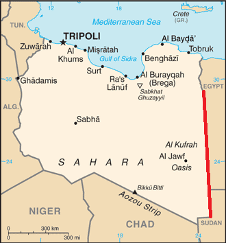
English: Map of Libya, showing the 25th meridian east as part of the border with Egypt and Sudan |
| Petsa | |
| Taudan | Based on map of Libya from CIA World Factbook |
| Mannurat | Bazonka; CIA |
Lisensia
This work is in the public domain in the United States because it is a work prepared by an officer or employee of the United States Government as part of that person’s official duties under the terms of Title 17, Chapter 1, Section 105 of the US Code.
Note: This only applies to original works of the Federal Government and not to the work of any individual U.S. state, territory, commonwealth, county, municipality, or any other subdivision. This template also does not apply to postage stamp designs published by the United States Postal Service since 1978. (See § 313.6(C)(1) of Compendium of U.S. Copyright Office Practices). It also does not apply to certain US coins; see The US Mint Terms of Use.
|
 | |
| Daytoy a papeles ket nainaganan a kas nawaya iti amin nga ammo a pakedngan babaen ti karbengan ti kopia a linteg, a mairaman amin a dagiti makaibagian ken karruba a karbengan. | ||
Pakasaritaan ti papeles
Pinduten iti petsa/oras tapno makita ti papeles a kas naiparang iti dayta a panawen.
| Petsa/Oras | Bassit a ladawan | Dagiti rukod | Agar-aramat | Komentario | |
|---|---|---|---|---|---|
| agdama | 18:38, 3 Oktubre 2012 | | 330 × 354 (25 KB) | Bazonka | User created page with UploadWizard |
Panagusar iti papeles
Ti sumaganad a panid ket agus-usar iti daytoy a papeles:
Global a panagusar ti papeles
Dagiti sumaganad a wiki ket agus-usar iti daytoy a papeles:
- Panagusar idiay bs.wikipedia.org
- Panagusar idiay ca.wikipedia.org
- Panagusar idiay el.wikipedia.org
- Panagusar idiay en.wikipedia.org
- Panagusar idiay es.wikipedia.org
- Panagusar idiay fa.wikipedia.org
- Panagusar idiay fr.wikipedia.org
- Panagusar idiay ja.wikipedia.org
- Panagusar idiay ko.wikipedia.org
- Panagusar idiay mk.wikipedia.org
- Panagusar idiay pt.wikipedia.org
- Panagusar idiay th.wikipedia.org
- Panagusar idiay zh.wikipedia.org