Papeles:Map of Europe 2007 (political) de.png

Kadakkel daytoy a panagipadas: 800 × 523 dagiti piksel. Sabali kadagiti resolusion: 320 × 209 dagiti piksel | 640 × 418 dagiti piksel | 1,024 × 669 dagiti piksel | 1,280 × 836 dagiti piksel | 1,596 × 1,043 dagiti piksel.
Kasisigud a papeles (1,596 × 1,043 dagiti piksel, kadakkel ti papeles: 109 KB, kita ti MIME: image/png)
| Daytoy ket papeles a nagtaud manipud idiay Wikimedia Commons. Ti pakaammo manipud iti bukodna a deskripsion a panid idiay ket naiparang dita baba. Ti Commons ket repositorio dagiti nawaya a nalisensiaan a midia. Mabalinmo ti tumulong. |
Pakabuklan
| Deskripsion |
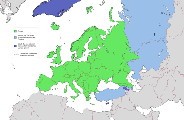
Deutsch: Geografische und politische Grenzen Europas (2007)
English: Geographical and political boundaries of Europe (2007). Note that the Caucasus watershed is not indicated correctly, it runs along Georgia's northern border. |
| Petsa | (UTC) |
| Taudan | |
| Mannurat |
|
| Dagiti sabali a bersion |
|


_de.png)
.png)


_de.png)
Lisensia
Siak, ti agtengtengel ti karbengan ti kopia iti daytoy nga obra, ket agipablaak babaen ti sumaganad a lisensia:
Daytoy a papeles ket nalisensiaan babaen ti Creative Commons Attribution 3.0 Unported a lisensia.
- Nawaya ka:
- ti makibingay – ti ag-kopia, agiwaras ken agipatulod ti obra
- ti pagtipon-tipon – ti panagibagay ti obra
- Babaen kadagiti sumaganad a kasasaad:
- pammadayaw – Nasken a mangtedka iti pammadayaw, mangited iti silpo iti lisensia, ken mangibaga no adda dagiti nabaliwan. Mabalinmo nga aramiden iti ania man a pamay-an, ngem iti san a waya a mangisingasing a mangigupit kenka wenno iti panagusarmo.
Kasisigud a listaan pang-ipan
This image is a derivative work of the following images:
- File:Map_of_Europe_(political).png licensed with GFDL
- 2009-02-03T09:46:18Z Koyos 1596x1043 (110005 Bytes) reverting geographically inaccurate color coding
- 2008-07-18T13:16:24Z Aegean Boy 1596x1043 (110096 Bytes) {{Information |Description= |Source= |Date= |Author= |Permission= |other_versions= }}
- 2008-06-20T15:03:21Z Westermarck 1596x1043 (110005 Bytes) {{Information |Description= |Source= |Date= |Author= |Permission= |other_versions= }}
- 2007-01-15T21:02:56Z Jon Harald Søby 1596x1043 (110089 Bytes) small change in Azerbaijan's colour
- 2006-12-03T14:06:17Z Electionworld 1596x1043 (117601 Bytes) {[ew|en|Alinor}} According to [[Transcontinental nation|one common view]] of the boundary, the European continent is the area coloured green on this map. The light blue/dark blue colors are described at [[Transcontinental nat
Uploaded with derivativeFX
Pakasaritaan ti papeles
Pinduten iti petsa/oras tapno makita ti papeles a kas naiparang iti dayta a panawen.
| Petsa/Oras | Bassit a ladawan | Dagiti rukod | Agar-aramat | Komentario | |
|---|---|---|---|---|---|
| agdama | 23:21, 15 Nobiembre 2009 | | 1,596 × 1,043 (109 KB) | Kolja21 | Abgleich mit engl. Fassung, s. Diskussionsseite |
| 02:41, 19 Pebrero 2009 |  | 1,596 × 1,043 (110 KB) | Kolja21 | == Summary == {{Information |Description= {{en|1=Political geography of Europe (2007)}} {{de|1=Geografische und politische Grenzen Europas (2007)}} |Source=*File:Map_of_Europe_(political).png |Date=2009-02-19 02:37 (UTC) |Author=*[[:File:Map_of_Euro |
.png)
Panagusar iti papeles
Awan ti pampanid nga agus-usar iti daytoy a papeles.
Global a panagusar ti papeles
Dagiti sumaganad a wiki ket agus-usar iti daytoy a papeles:
- Panagusar idiay de.wikipedia.org
_de.png)