Papeles:Mount Malinao.jpg
Awan ti mabalin a nangatngato a resolusion.
Mount_Malinao.jpg (640 × 416 dagiti piksel, kadakkel ti papeles: 43 KB, kita ti MIME: image/jpeg)
| Daytoy ket papeles a nagtaud manipud idiay Wikimedia Commons. Ti pakaammo manipud iti bukodna a deskripsion a panid idiay ket naiparang dita baba. Ti Commons ket repositorio dagiti nawaya a nalisensiaan a midia. Mabalinmo ti tumulong. |
Pakabuklan
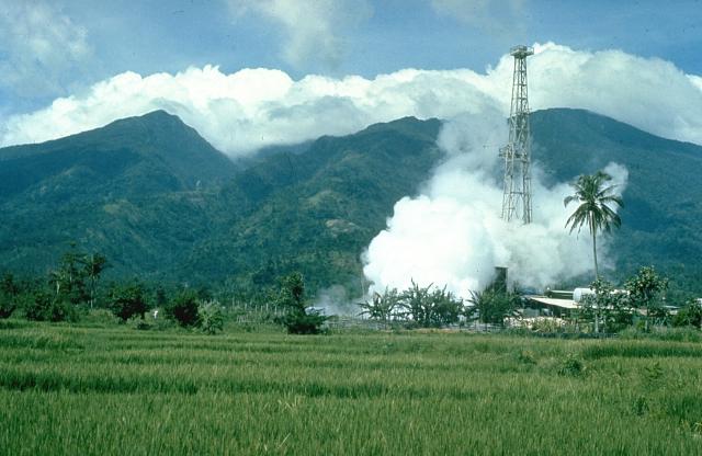
| Deskripsion | Mount Malinao is a forested stratovolcano with a summit crater that is breached to the east. The Tiwi geothermal field, seen here with the volcano in the background, is located on the east flanks of Malinao. The geothermal field is located near Luzon's largest fumarole field, which includes siliceous sinter deposits at Naglabong. |
| Petsa | Di ammo a petsa |
| Taudan | http://www.volcano.si.edu/world/volcano.cfm?vnum=070304=A&volpage=photos&photo=018037 |
| Mannurat | Chris Newhall (U.S. Geological Survey) |
Lisensia
This image is in the public domain in the United States because it only contains materials that originally came from the United States Geological Survey, an agency of the United States Department of the Interior. For more information, see the official USGS copyright policy.
|
Pakasaritaan ti papeles
Pinduten iti petsa/oras tapno makita ti papeles a kas naiparang iti dayta a panawen.
| Petsa/Oras | Bassit a ladawan | Dagiti rukod | Agar-aramat | Komentario | |
|---|---|---|---|---|---|
| agdama | 18:00, 11 Oktubre 2010 | | 640 × 416 (43 KB) | Michael Metzger | {{Information |Description=Mount Malinao is a forested stratovolcano with a summit crater that is breached to the east. The Tiwi geothermal field, seen here with the volcano in the background, is located on the east flanks of Malinao. The geothermal field |
Panagusar iti papeles
Ti sumaganad a panid ket agus-usar iti daytoy a papeles:
Global a panagusar ti papeles
Dagiti sumaganad a wiki ket agus-usar iti daytoy a papeles:
- Panagusar idiay arz.wikipedia.org
- Panagusar idiay bcl.wikipedia.org
- Panagusar idiay cs.wikipedia.org
- Panagusar idiay de.wikipedia.org
- Panagusar idiay en.wikipedia.org
- Panagusar idiay fa.wikipedia.org
- Panagusar idiay fr.wikipedia.org
- Panagusar idiay lld.wikipedia.org
- Panagusar idiay nl.wikipedia.org
- Panagusar idiay www.wikidata.org