Ramallah
Ti Ramallah (Arabiko: رام الله, maibalikas a kas Rāmallāh ![]() (tulong·pakaammo)) ket ti siudad ti Palestina idiay sentral a West Bank a mabirukan iti 10 km (6 milia) iti amianan ti Herusalem iti maysa a natimbeng a kangato iti 880 metro iti pantar ti baybay, ken asideg daytoy iti al-Bireh. Daytoy ket agdama nga agserbi a kas ti de facto nga administratibo a kapitolio ti Nailian a Turay ti Palestina (PNA). Ti Ramallah ket historikal idi a maysa nga ili ti Kristiano nga Arabo. Ita nga aldaw dagiti Muslim ket ti kaaduan a mangporma ti populasion iti gangani a 27,902 nga agtataengbabaen idi 2007,[2] ken agraman dagiti Kristiano a mangbukel iti kaaduan kadagiti minoridad.
(tulong·pakaammo)) ket ti siudad ti Palestina idiay sentral a West Bank a mabirukan iti 10 km (6 milia) iti amianan ti Herusalem iti maysa a natimbeng a kangato iti 880 metro iti pantar ti baybay, ken asideg daytoy iti al-Bireh. Daytoy ket agdama nga agserbi a kas ti de facto nga administratibo a kapitolio ti Nailian a Turay ti Palestina (PNA). Ti Ramallah ket historikal idi a maysa nga ili ti Kristiano nga Arabo. Ita nga aldaw dagiti Muslim ket ti kaaduan a mangporma ti populasion iti gangani a 27,902 nga agtataengbabaen idi 2007,[2] ken agraman dagiti Kristiano a mangbukel iti kaaduan kadagiti minoridad.
Ramallah | |
|---|---|
Kita ti Munisispalidad A (Siudad) | |
| Transkripsion nga Arabiko | |
| • Arabiko | رام الله |
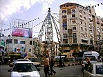
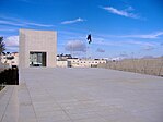
Agpakanawan manipud iti ngato: Buya ti Ramallah ken ti tengnga a meskita, mausoleo ni Arafat, Simbaan Ni Apo Baket ti Asunsion, dagiti tidda ti Romano, Kuadrado ti Al-Manara | |
Lokasion ti Ramallah iti kaunegan ti Palestina | |
| Nagsasabtan: 31°54′N 35°12′E / 31.900°N 35.200°ENagsasabtan: 31°54′N 35°12′E / 31.900°N 35.200°E | |
| Grid ti Plestina | 168/145 |
| Estado | Estado ti Palestina |
| Gobernorato | Ramallah ken al-Bireh |
| Gobierno | |
| • Kita | Siudad (manipud idi 1995) |
| • Daulo ti MUnisipalidd | Musa Hadid |
| Kalawa | |
| • Kita ti Munisispalidad A (Siudad) | 16,344 dunams (16.3 km2 wenno 6.3 sq mi) |
| Populasion (2017)[1] | |
| • Kita ti Munisispalidad A (Siudad) | 38,998 |
| • Densidad | 2,400/km2 (6,200/sq mi) |
| • Metro | 153,237 |
| Website | www.ramallah.ps |
Etimolohia
urnosenTi "Ramallah" ket buklen ti "Ram," ti maysa a balikas ti Arameo a ti kayatna a sawen ket "nangato a lugar wenno bantay," ken "Allah," ti Arabiko a balikas para iti Dios,[3] ken no iraman dagitoy dua a balikas ti napno a kaibuksilanna ket "ti Turod ti Dios".[4]
Pakasaritaan
urnosenDagiti tabon iti nakitikit a bato ket nabirukanen idiay asideg ti Ramallah.[5] Dagiti pirgis ti damdamili manipud iti Krusada/Aybi ken ti nasapa a paset ti panawen ti Otomano ket nabirukan pay idiay.[6]
Ti Ramallah ket nainagananen a mairaman iti lugar ti Krusada a tinawtawagan iti Ramalie.[7][8] Adda pay dagiti nailasin a tidda ti pasdek nga addaan iti naarko a ruangan manipud iti panawen ti Krusada a tinawtawagan iti al-Burj,.[9] ngem ti kasisigud nga usar ti pasdek ket saan pay a naikeddeng.[10]
Dagiti nagibasaran
urnosen- ^ "Main Indicators by Type of Locality - Population, Housing and Establishments Census 2017" (PDF). Palestinian Central Bureau of Statistics (PCBS). Naiyarkibo (PDF) manipud iti kasisigud idi Enero 28, 2021. Naala idi 2021-01-19.
- ^ 2007 PCBS Population Naiyarkibo Nobiembre 21, 2017, iti Wayback Machine. Palestinian Central Bureau of Statistics. p.53. (Arabiko)
- ^ "Ramallah.ps". Ramallah.ps. Naiyarkibo manipud iti kasisigud idi 2011-11-05. Naala idi Nobiembre 13, 2011.
- ^ Palmer, 1881, p. 324
- ^ Conder and Kitchener, 1883, SWP III, p. 155
- ^ Finkelstein et al, 1997, p. 353
- ^ Rey, 1883, p. 389
- ^ Prawer and Benvenisti, 1970, cited in Finkelstein and Lederman, 1997, p. 353
- ^ Pringle, 1997, p. 90
- ^ Pringle, 1997, p. 12
Bibliograpia
urnosen- Barron, J. B., ed. (1923). Palestine: Report and General Abstracts of the Census of 1922 (PDF). Government of Palestine.
- Conder, Claude Reignier; Kitchener, H. H. (1883). The Survey of Western Palestine: Memoirs of the Topography, Orography, Hydrography, and Archaeology. Vol. 3. London: Palestine Exploration Fund.
- Department of Statistics (1945). Village Statistics, Abril, 1945. Government of Palestine.
- Finkelstein, Israel; Lederman, Zvi, dagiti ed. (1997). Highlands of many cultures. Tel Aviv: Institute of Archaeology of Tel Aviv University Publications Section. ISBN 965-440-007-3.
- Grant, E. (1926). "Ramallah. Signs of the early occupation of this and other sites". Quarterly statement – Palestine Exploration Fund: 186–195.
- Guérin, Victor (1875). Description Géographique Historique et Archéologique de la Palestine (iti Pranses). Vol. 2: Samarie, pt. 2. Paris: L'Imprimerie Nationale. (pp. 40- 41)
- Hadawi, Sami (1970). Village Statistics of 1945: A Classification of Land and Area ownership in Palestine. Palestine Liberation Organization Research Center.
- Hütteroth, Wolf-Dieter; Abdulfattah, Kamal (1977). Historical Geography of Palestine, Transjordan and Southern Syria in the Late 16th Century. Erlanger Geographische Arbeiten, Sonderband 5. Erlangen, Germany: Vorstand der Fränkischen Geographischen Gesellschaft. ISBN 3-920405-41-2.
- Mills, E., ed. (1932). Census of Palestine 1931. Population of Villages, Towns and Administrative Areas (PDF). Jerusalem: Government of Palestine.
- Palmer, E. H. (1881). The Survey of Western Palestine: Arabic and English Name Lists Collected During the Survey by Lieutenants Conder and Kitchener, R. E. Transliterated and Explained by E.H. Palmer. Palestine Exploration Fund.
- Pringle, Denys (1997). Secular buildings in the Crusader Kingdom of Jerusalem: an archaeological Gazetter. Cambridge University Press. ISBN 0521 46010 7.
- Rey, Emmanuel Guillaume (1883). Les colonies franques de Syrie aux XIIme et XIIIme siècles (iti Pranses). Paris: A. Picard.
- Robinson, Edward; Smith, Eli (1841). Biblical Researches in Palestine, Mount Sinai and Arabia Petraea: A Journal of Travels in the year 1838. Vol. 2. Boston: Crocker & Brewster.
- Shaheen, Azeez (1982): Ramallah: Its history and genealogies. Birzeit University Press
Dagiti akinruar a silpo
urnosen Dagiti midia a mainaig iti Ramallah iti Wikimedia Commons
Pakaammo ti panagbiahe idiay Ramallah manipud iti Wikivoyage (iti Ingles)
- Siudad ti Ramallah Naiyarkibo 2012-10-16 iti Wayback Machine


